
From paper to pixels, our favorite navigation system was still analog — Carmen and her atlas.
How the world changed beneath our wheels.
I was sorting through a box of old trip photos the other day — glossy 4×6 time capsules from a different century — when it hit me. Uncharted Moments isn’t just a story about where we went. It’s also about how the world changed beneath our wheels.
As Carmen and I followed the Lewis and Clark Trail, the technology around us evolved almost as quickly as the landscapes we drove through. What started as paper maps and mix CDs became satellite-guided routes, digital playlists, and cloud-backed memories.
It’s funny: while we were tracing the past, the future was quietly catching up to us.
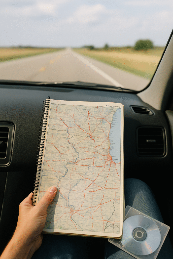
Finding Our Way
In those early years, “navigation” meant one thing — MapQuest printouts. Six or seven pages of turn-by-turn directions so detailed they could’ve guided a lunar landing.
Carmen would sit in the passenger seat, papers spread across her lap, reading aloud like an auctioneer:
“Take ramp toward I-70 West. Go 0.1 miles. Merge onto I-70 West. Go 23.4 miles.”
Halfway through the second page, she’d look up and sigh.
“Didn’t we just do that?”
She wasn’t wrong. MapQuest had trust issues. It narrated everything. Getting off the ramp, getting back on, continuing straight. God help you if you missed a turn; by the time you found your place again, you’d already reached the next state.
Then came Microsoft Streets & Trips, which let us print maps with tidy flags and pastel highlights. I spent hours fine-tuning those routes — optimizing waypoints like I was planning a corporate network migration.
Eventually, we graduated to the Garmin GPS, that small oracle on the dashboard. “Recalculating…” became part of our soundtrack. When we upgraded to a BlackBerry with GPS, it felt like we were driving inside The Jetsons.
And yet, through all of it, Carmen never let go of her Rand McNally Atlas. The maps for each state were folded, worn, and lined with her notes — our analog breadcrumb trail.
Her skill with those maps bordered on the mystical. Once, using nothing but Granny’s journal and her atlas, she located the exact spot of my grandmother’s childhood farmhouse.
“If it’s four and a half miles northwest of here, and four northeast of there,” she said, tracing her finger over Pierce County, “then it must be right… here.”
Moments later, the farmhouse appeared on the left.
You don’t get that kind of magic from a GPS.
The Soundtrack of the Road
Our soundtrack evolved just like our maps.
In the beginning, it was FM radio — finding a station, losing it to static, scanning for something new. Carmen could sense a signal fading like a storm front.
We carried a massive CD binder, with Carmen as our DJ—the Stones, Clapton, Seger — the soundtrack of a thousand miles. On one trip, Sirius launched an all-Stones channel, and we made a game of it: we’d try to guess whether the next song would be by the Rolling Stones.
Of course, it always was. And every time, we’d laugh like kids.
Satellite radio felt like a revelation — hundreds of channels, coast to coast, no static. Later came streaming: Pandora, then Spotify, each algorithm learning our moods, our memories, our mile markers.
Still, I miss the surprise of radio. That serendipity when the perfect song just finds you on the open road.
Capturing the Moment
If navigation told us where we were going, and music carried how we felt, then photos preserved what we saw.
Our first trips were shot on 35mm film — 24 exposures per roll, every click a small gamble. We’d drop them at Walgreens and wait days, sometimes weeks, to find out if we’d actually captured the hawk, the river, the laugh.
Then came the digital camera, with its tiny 2×2 screen that gave you just enough feedback to think, maybe.
Later, our hard drives became overloaded with folders named “Trip3_FINAL” and “Trip3_REALLYFINAL.” We took more photos than we could ever sort — tens of thousands of them. Carmen was the master captioner, turning each image into a story: equal parts wit and wonder.
Now, our phones do it all — cameras sharper than anything we dreamed of thirty years ago, every image backed up to the cloud within seconds. Convenient, yes. But sometimes I miss the feel of a print — the weight of memory in your hand.
Then and Now
Somewhere between MapQuest and Google Maps, FM and Spotify, 35mm and the cloud, our story unfolded — not because of the technology, but in spite of it.
We found our way together. We learned to listen. We captured the moments that mattered.
The tools changed. The wonder didn’t.
And after all those years as a CIO chasing the next upgrade, I’ve realized something simple:
Sometimes the best innovation is still just looking out the window — together — and saying, “Proceed on.”